
Mr. Nguyen Van Thom, 45 years old, in An Giang admits that he is sensitive to all changes from the Mekong River. His family lived for many years in Tonle Sap Lake (Cambodia) and then migrated downstream to An Giang. Many generations have lived on the river, he clearly sees that over the past 20 years the river has “gone out of tune”.
In 2019, when he heard relatives in Cambodia complain that fish and shrimp resources were increasingly depleted, and the water of Tonle Sap Lake suddenly changed color from brown to green, he immediately understood the problem. The river is green, meaning there is no more silt, just hungry water. The further downstream you go, the more severe the “hunger” will be.
“The Cambodian proverb says that wherever there is water, there are fish. But it seems that this delta doesn’t really have water anymore,” he concluded.
People like Mr. Thom depend on the river to live, and the river is influenced by the upstream.
Before 1990, on average each year the Mekong River transported 160 million tons of fine, suspended silt in the water and 30 million tons of sand and gravel at the river bottom to the Mekong Delta. This is an important resource that has nourished rivers, seas and more than 30,000 km of artificial canals in the Mekong Delta for thousands of years.
From one of the most fertile lands in the world, over the past two decades, this source of nutrients has been increasingly depleted, causing the Mekong Delta to fall into constant landslides. The rate of accretion cannot keep up with erosion, and as a result, the young delta is shrinking. Over thousands of years, the delta expanded at a rate of 16 square kilometers – about 3,000 football fields – per year. Now, in the same period, it has lost an average of 5 square kilometers of land, equivalent to 926 football fields.
“One side erodes and the other side accretes is a natural law from ancient times in the process of forming the Mekong Delta. But overall, the Mekong Delta always expands due to more accretion,” said Master Nguyen Huu Thien, an independent expert. Over 20 years of research and analysis on the Mekong Delta.
On average, each year, silt and sand travel 200 km on the Mekong River during the flood season, which is from July to September every year. It took 20-30 years for these sediments to travel the 4,400 km journey from China to Vietnam. When reaching downstream, the flow carrying sand and gravel will both erode and build up the riverbank according to the principle of “erosion on concave banks, accretion on convex banks”. Meanwhile, smaller sand, lighter silt and fine mud pour into the sea. Some of this will settle at the river mouth, helping to expand the territory, and also be a layer of “armor” that covers the delta from the landslide impact of ocean waves.
However, this rule was no longer true when the rate of sedimentation and landslides reached a balance in 1990. By 2005, landslides had dominated, causing the delta to gradually “shrink”, according to research by the Southern Institute of Water Resources Science. (SIWRR).
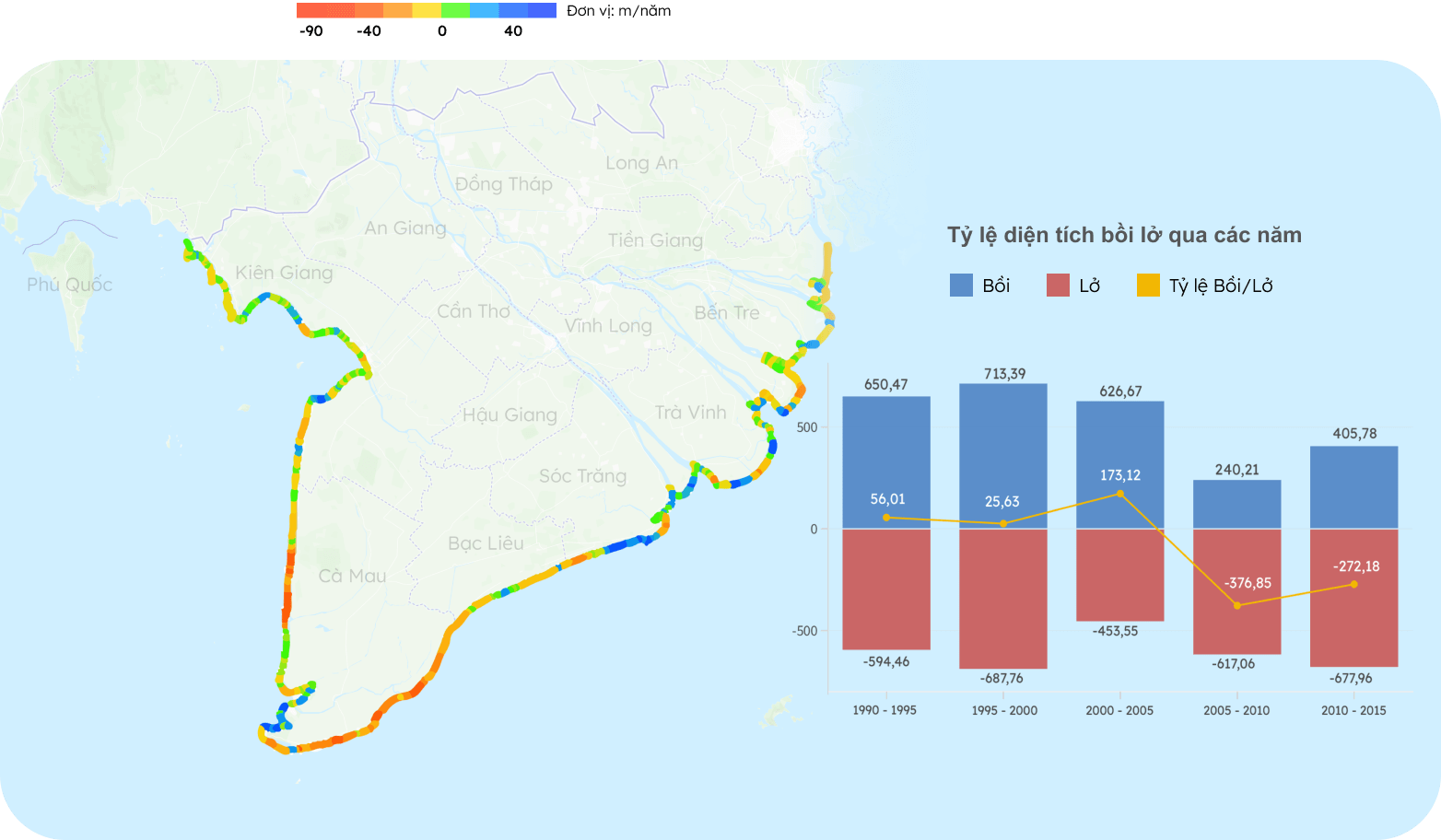
Coastline change rate in the period 1990 – 2015
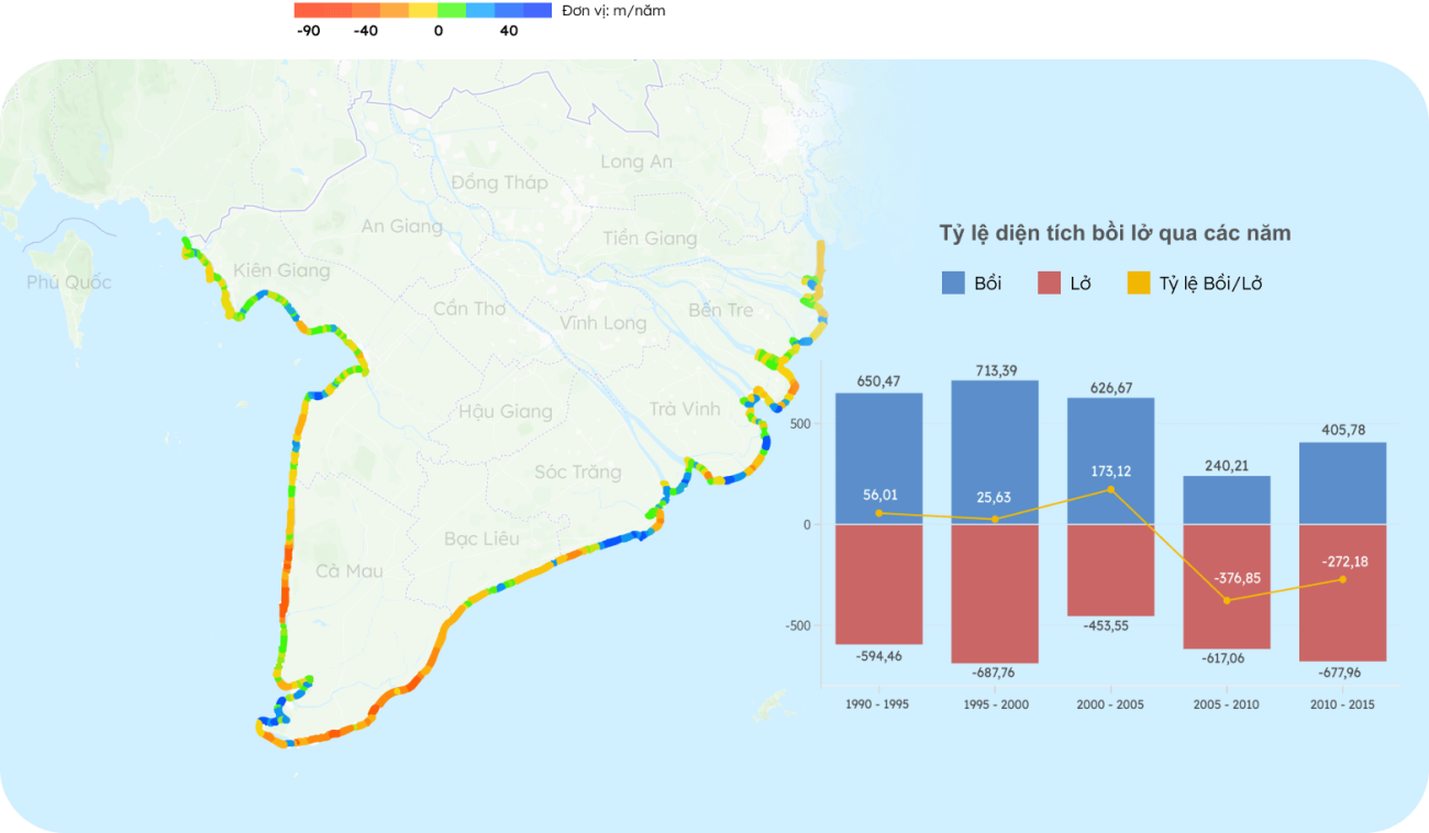
Specifically, in the period 1973-1995, this delta had an average sedimentation rate of 7.2 m per year. Over the next 10 years, this number decreased to about 2.8 m. In the period 2005-2015, the sedimentation-erosion ratio dropped to negative 1.4 m per year, marking a reversal when erosion was more than sedimentation. 68% of the total length of the Mekong Delta coastline has landslides.
This was also the period when Mr. Thom’s newly built house, less than three years old, began to be “corroded” by the river, falling half into the canal in a landslide in 2001. The banks of the Cai Vung River have since continuously eroded. becoming one of hundreds of hot spots in the Mekong Delta.
According to expert Nguyen Huu Thien, the main reason why landslides prevail is because the Mekong River lacks silt, sand, and gravel – the main materials that create the shape of the delta today.
The Mekong River Commission determined that since 1994, the annual amount of sediment flowing downstream has decreased by more than 300% – from 160 million tons (1992) to 47.4 million tons (2020). This agency predicts that by 2040, only 4.5 million tons of sediment will flow to the Mekong Delta, a decrease of 36 times compared to 1992 (160 million tons). Some extreme forecasts also suggest that when downstream hydroelectric dams are completed, 100% of the sand and gravel moving at the river bottom will be completely retained by the dams.
After 6,000 years, what is known as one of the most fertile deltas in the world, is falling into a “starvation” of sediment as sediment becomes trapped upstream.
The amount of sediment decreases when there are more hydroelectric dams along the Mekong River
The amount of upstream alluvium in the Mekong Delta has decreased significantly since 1993 – when the Mekong’s first hydroelectric dam – Man Loan – was built on the Lan Thuong waterfall (China). In the future, 4,350 km along the Mekong River will have more than 400 hydroelectric dams operating, retaining most of the silt upstream.
Along with that, the occurrence of landslides in the Mekong Delta also began to increase significantly, from less than 100 landslides (before 2012) to about 600 today. Erosion of river banks, canals, and ditches is concentrated in upstream provinces such as An Giang, Dong Thap and transition areas between tidal and upstream areas such as Can Tho, Tien Giang, Vinh Long, to the coast. like Ca Mau and Soc Trang.
“The Mekong Delta is bleeding land much faster than other deltas in the world,” said Marc Goichot, Head of the Freshwater Program of the World Wide Fund for Nature (WWF) in the Asia Pacific region. Duong, warning.
He cited delta regions such as the Rhine River (Netherlands) and Mississippi (USA) that are all at a stage of experiencing a series of problems like the Mekong Delta. However, while other countries took more than 100 years to face this stressful situation, Western Vietnam only took 20-30 years.
The loss of land in the Delta will lead to a series of consequences such as loss of fresh water, reduced agricultural productivity, collapsed infrastructure, and thus the livelihoods of 17 million people will be at risk.
Number of landslides and length of 13 Western provinces from 2017 to present
The Mekong Delta is increasingly narrowing not only due to landslides, but is also sinking at an average rate of more than 1 cm per year – 3 to 8 times the increase in sea level.
Research by Dr. Rafael Schmitt (Stanford University) and colleagues in 2021 shows that 23 to 90% of the delta will be submerged under the ocean by 2100, depending on sedimentation, groundwater levels and sea level rise. This delta is among the three most vulnerable deltas in the world, and will gradually disappear in the next 80 years. In the lower Mekong, this is the last place to appear, but will disappear first when sea levels rise, and the ocean embraces this delta again as it did 6,000 years ago.
“People and deltas are very intertwined. As the deltas were built up, civilizations also emerged. It’s scary to think what could happen if the deltas disappeared,” he said. Goichot said.
Content: Thu Hang – Ngoc Tai – Hoang Nam
Graphics: Hoang Khanh – Thanh Ha
About data:
This article was written with the advice of independent expert on the Mekong Delta, Nguyen Huu Thien; Southern Institute of Water Resources Science; and use materials from research:
- The process of forming the Mekong Delta (2008). Le Xuan Diem
- The role of sedimentation and natural compaction in a prograding delta: insights from the mega Mekong delta, Vietnam (2018). Claudia Zoccarato, Philip S. J. Minderhoud & Pietro Teatini
- Report on land subsidence and erosion in the Mekong Delta, current situation, causes and solution orientation (2017). Ministry of Agriculture and Rural Development
- Analysis of the causes of increased river bank erosion in the Mekong Delta (2019). Huynh Cong Hoai, Nguyen Thi Bay, Dao Nguyen Khoi, Tra Nguyen Quynh Nga
- The data in the article is taken from the Southern Institute of Water Resources (SIWRR), Mekong River Commission (MRC)
- The location of hydroelectric dams is based on the project’s monitoring system within the Mekong Water Data Initiative (MWDI), which specializes in collecting and analyzing data on water management.


